Slope engineering in Bakersfield encompasses the comprehensive analysis, design, and stabilization of natural and man-made slopes to mitigate landslide risks, prevent erosion, and ensure the long-term safety of infrastructure and property. Given the city's position at the southern end of the San Joaquin Valley and its proximity to the seismically active Sierra Nevada foothills and Tehachapi Mountains, unstable terrain poses a persistent challenge for residential developments, transportation corridors, and energy facilities. This category covers everything from initial site reconnaissance and subsurface investigation to the implementation of robust stabilization measures, including slope stability analysis, anchored systems, and structural retaining solutions.
The local geology of Bakersfield is dominated by Quaternary alluvial deposits overlying the Kern River Formation, with significant areas of moderately cemented sandstone, siltstone, and shale in the adjacent uplands. These materials are highly susceptible to weathering, shrink-swell behavior, and strength loss when saturated, particularly in the clay-rich units of the Etchegoin and San Joaquin formations. Seasonal precipitation, though infrequent, can trigger rapid surface erosion and shallow debris flows on oversteepened cut slopes, while prolonged drought cycles desiccate expansive soils, creating deep fissures that compromise slope integrity. Additionally, the region's high seismicity—driven by the nearby San Andreas, Garlock, and White Wolf fault zones—introduces a critical dynamic loading condition that must be factored into every slope design.
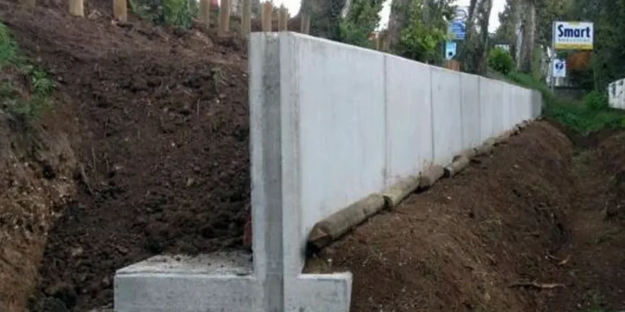
Compliance with the California Building Code (CBC), specifically Chapter 18 on Soils and Foundations, and the California Geological Survey's guidelines for seismic hazard zones is mandatory for any slope project in Bakersfield. The city enforces strict grading ordinances under its Municipal Code Title 17, requiring geotechnical reports that address global stability, surficial stability, and drainage management for slopes steeper than 5:1 (horizontal:vertical) or exceeding 5 feet in height. For projects within mapped earthquake-induced landslide zones, the Seismic Hazards Mapping Act mandates site-specific evaluations that often necessitate active/passive anchor design to achieve acceptable factors of safety under pseudostatic conditions.
This category serves a wide array of project types, from stabilizing backyard slopes for custom homes in the bluffs of Kern River Canyon to designing high-capacity tieback systems for highway widening along State Route 178. It is equally critical for commercial developments in the fast-growing northwest sector, where deep excavations require temporary shoring and permanent retaining wall design to support grade separations. Agricultural water conveyance canals traversing sloping terrain in the eastern county also demand erosion control and slope armoring, while solar farm installations on undulating ground rely on micro-scale stability assessments to prevent foundation movement. Each application demands a tailored approach that integrates subsurface data, structural mechanics, and hydraulic considerations into a unified design.
Common questions
What are the key warning signs that a slope in Bakersfield may be unstable?
Common indicators include tension cracks at the top of the slope, bulging or slumping at the toe, leaning or tilting retaining structures, and new seeps or saturated ground. In Bakersfield's expansive clay soils, irregular pavement cracking near the crest and doors or windows that begin to stick in adjacent structures can also signal slope movement requiring professional evaluation.
How does Bakersfield's seismic activity influence slope design requirements?
The proximity to active faults means slope designs must incorporate pseudostatic seismic coefficients as specified by the California Building Code. Engineers perform dynamic stability analyses to ensure slopes can withstand earthquake-induced ground shaking without catastrophic failure, often requiring higher factors of safety and more robust stabilization measures like deep anchors or reinforced earth structures.
What role does drainage play in Bakersfield slope stability?
Drainage is critical because Bakersfield's silty and clayey soils lose significant shear strength when saturated. Proper surface water diversion, subsurface drains, and erosion control measures prevent water infiltration that triggers shallow failures. Even well-engineered slopes can fail if drainage is neglected, making it a primary focus during both design and long-term maintenance.
When does a property owner in Bakersfield need a slope stability analysis?
A geotechnical slope stability analysis is typically required when grading plans propose cuts or fills steeper than 5:1, when building near the top or toe of an existing slope, or when property lies within a state-mapped seismic hazard zone. Lenders and insurers may also mandate an analysis before financing hillside construction to confirm the site meets safety standards.